Get Directions
Below are the directions to our Shem Creek and Crab Bank Island Location. If you are scheduled for a different tour please call us for directions or click below if you know your tour name.
Saltwater Tour Directions
Shem Creek Shrimping Village and Crab Bank Island Preserve
Capers Island State Heritage Preserve
Blackwater Tour Directions
Quenby Creek Landing
Huger Creek Landing
ACE Basin - Penny Creek/Willtown Bluff
Edisto River
Wadboo Creek
Directions to Shem Creek
Shem Creek marsh, harbor and Crab Bank Island Location Click here
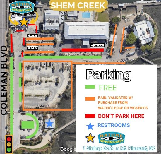
On Shem Creek in Mt. Pleasant, South Carolina (Our next door neighbor is the Shem Creek Inn.)
You can GPS in Shrimp Boat Lane, Mt. Pleasant, SC 29464 - adjacent to Mt. Pleasant Seafood
and it will take you into our parking lot on Shem Creek. We only have public parking which is along Coleman Blvd, down the sides of Shrimp Boat Ln (in non Waters Edge spots) and near the park if you plan to walk the boardwalk at all.
(843)647-7800
From Downtown Charleston
Take Either Meeting Street or East Bay Street North and get onto Hwy. 17 North towards Mt. Pleasant (Georgetown) and go over the Arthur Ravenel Bridge. Get into your right lanes and exit off onto Coleman Blvd. Go to the 4th traffic light and turn RIGHT into the parking lot. Park anywhere in the public right of way along Shrimp boat lane. Shrimp Boat Lane is the paved portion coming into the parking lot. You can face Coleman Blvd, or park along the islands next to the road. Shrimp boat lane continues all the way down to Vickerys. It is public right of way all the way down to Vickerys on each side of the paved street. Approx. 8-10 minutes
From Kiawah and Seabrook Islands
Follow Main road out of the islands to the first traffic light at River Road. Turn RIGHT on River road and take approx. 11 miles to Maybank Hwy. Turn RIGHT on Maybank Hwy. and take to the end (approx. 3-4 miles). Turn LEFT onto (Folly Road) towards Downtown Charleston and continue to the RIGHT following signs to Hwy. 17 North..... Get onto Hwy. 17 North towards Mt. Pleasant (Georgetown) and go over the Arthur Ravenel Bridge. Get into your right lanes and exit off onto Coleman Blvd. Go to the 4th traffic light and turn RIGHT into the parking lot. Park anywhere in the public right of way along Shrimp Boat Lane. Shrimp Boat lane is the paved portion coming into the parking lot. You can face Coleman Blvd, or park along the islands next to the road. Shrimp boat lane continues all the way down to Vickerys. It is public right of way all the way down to Vickerys on each side of the paved street. Approx. 40 minutes (26 miles)
From James Island / Folly Beach
Take Folly Road towards Downtown Charleston and continue to the RIGHT following signs to Hwy. 17 North..... Get onto Hwy. 17 North towards Mt. Pleasant (Georgetown) and go over the Arthur Ravenel Bridge. Get into your right lanes and exit off onto Coleman Blvd. Go to the 4th traffic light and turn RIGHT into the parking lot. Park anywhere in the public right of way along Shrimp Boat Lane. Shrimp Boat lane is the paved portion coming into the parking lot. You can face Coleman Blvd, or park along the islands next to the road. Shrimp boat lane continues all the way down to Vickerys. It is public right of way all the way down to Vickerys on each side of the paved street. Approx. 25-35 minutes.
From Sullivan's Island and Isle of Palms
Take Palm Blvd. from the IOP towards Sullivans Island. It will turn into Jasper Blvd. once on Sullivan's. You will soon pass a Blue water tower on your left and will come to a stop sign. Turn Right at this stop sign onto (703) Ben Sawyer Blvd. towards Mt. Pleasant/ Charleston. (You will cross over the Ben Sawyer Bridge)... It will become Coleman Blvd as you are heading towards Mt. Pleasant. Go through several lights continuing past the Moultrie Plaza on your right and Arts Bar on your left. Continue on Coleman and go over the small BRIDGE (this will be Shem Creek). You will see our sign "Nature Kayak Adventures" on your left adjacent to Mt. Pleasant Seafood. Turn LEFT into the parking lot at the light at the bottom of the bridge. Park anywhere in the public right of way along Shrimp boat lane. Shrimp Boat Lane is the paved portion coming into the parking lot. You can face Coleman Blvd, or park along the islands next to the road. Shrimp boat lane continues all the way down to Vickerys. It is public right of way all the way down to Vickerys on each side of the paved street. Approx. 10-15 minutes.
From Mt. Pleasant Hwy 17 area
Take Hwy. 17 to Chuck Dawley Blvd ramp towards the business district of Mt. Pleasant...... Chuck Dawley Blvd. is located under the overpass near the Walmart off of Hwy. 17 . Take Chuck Dawley to the end and turn RIGHT onto Coleman Blvd. Go through several lights continuing past the Moultrie Plaza on your right. Get into your left lane and Continue on Coleman and go over the small BRIDGE (this will be Shem Creek). You will see our sign on your left adjacent to Mt. Pleasant Seafood. Turn LEFT into the parking lot at the light at the bottom of the bridge. Park anywhere in the public right of way along Shrimp boat lane. Shrimp Boat Lane is the paved portion coming into the parking lot. You can face Coleman Blvd, or park along the islands next to the road. Shrimp boat lane continues all the way down to Vickerys. It is public right of way all the way down to Vickerys on each side of the paved street. Approx. 10-15 minutes.
From North Charleston
Take I-26 to I-526 Towards Mt. Pleasant and it will end in Mt. Pleasant and turn into Chuck Dawley Blvd. Take Chuck Dawley to the end and turn RIGHT onto Coleman Blvd. Go through several lights continuing past the Moultrie Plaza on your right and Arts Bar on your left. Continue on Coleman a few more lights and go over the small BRIDGE (this will be Shem Creek). You will see our sign on your left adjacent to Mt. Pleasant Seafood. Turn LEFT into the parking lot at the light at the bottom of the bridge. Park anywhere in the public right of way along Shrimp boat lane. Shrimp Boat Lane is the paved portion coming into the parking lot. You can face Coleman Blvd, or park along the islands next to the road. Shrimp Boat Lane continues all the way down to Vickerys. It is public right of way all the way down to Vickerys on each side of the paved street. Approx. 20-30 minutes
Capers Island State Heritage Preserve
Garris Landing in Awendaw
To Garris Landing North End of Capers - Awendaw, SC
From Charleston:
Take hwy. 17 North through Mt. Pleasant. When you get past the WANDO high school area about 3 miles + start looking for a MARSH. AT the end of this marsh is a sign pointing to your RIGHT to go to GARRIS Landing and to the Bull Island Ferry. Turn RIGHT onto Sewee Road and go about 3 miles and look for a sign pointing to your RIGHT to turn onto Bulls Island road to get to the landing. Take Bulls Island road about 1 mile to the end. This is your landing. 35 minutes
From Myrtle Beach:
Take Hwy. 17 South and come through McClellanville. You will come into the area of “Awendaw”……. Look for a BILLBOARD on your Left and the Awendaw Grocery store. Turn LEFT onto Doar Rd;. next to them. Take and immediate RIGHT onto Sewee Road. Stay on Sewee Rd. about 3 miles miles and look for a sign pointing to your left to turn onto Bull Island road to the landing. Take this road about 1 mile to the end. This is your landing. Approximately one hour and 20 minutes - one hour and 40 minutes
Overnight parking is not permitted here. If an overnight is desired, we can assist with shuttle service.
Gadsdenville Landing in Mt. Pleasant
To: Copahee Sound Access/Gadsdenville Landing South End of Capers - Mt. Pleasant, SC
From Charleston:
Take Hwy. 17 North through Mt. Pleasant. When you get on the outskirts of town, you will go past the KOA on your right and then look for BERKELEY Electric Company. Look for a sign that says “Copahee sound Access”. Take a RIGHT onto GADSDENVILLE Road a little ways up from the Berk. Elec. Company. The road will end in about 1 mile. Go STRAIGHT and this will end at your landing. *There will be a $5/ fee per car to park here.
From Myrtle Beach:
Take Hwy. 17 South through McClellanville and Awendaw. You will soon be coming into the area of Mt. Pleasant. Look for a sign that states Copahee Sound Access. Turn LEFT onto Gadsdenville Road. . The road will end in about 1 mile. Go STRAIGHT and this will end at your landing. *There will be a $5/ fee per car to park here.
Quenby Creek Landing
Quenby Creek Landing, Cainhoy Road, Huger, SC 29450
From Charleston:
Take Hwy. 17 North through Mt. Pleasant. From the foot of the Arthur Ravenel bridge, go about 8 miles and turn LEFT onto hwy. 41. There is a Jack's Cosmic dogs on your right and a KFC on your left just before the light. Go 16+ miles up Hwy. 41 and turn LEFT onto Cainhoy Road. This road will be right after you see a sign for Hwy. 402. Do NOT go to 402, or you’ve gone too far!
After turning LEFT onto Cainhoy Road go over the RR tracks and the landing will be up on your right within 1/10 of a mile. Approx. 30-35 minutes. *Note that about 10 miles up Hwy. 41 there will be a veer off to your left point towards “Cainhoy”….. and I-526.. Ignore this and make sure you go that 16 miles “up hwy. 41”.
From North Charleston:
Take I-526 towards Mt Pleasant and get off of the Clements Ferry Road North Exit. Go 7.8 miles and turn LEFT onto Reflectants drive. Go ½ mile to the stop sign and Red blinking light and turn LEFT onto hwy. 41. Go about 10+ miles and turn LEFT onto Cainhoy Road. This road will be right after you see a sign for Hwy. 402. Do NOT go to 402, or you’ve gone too far!
After turning LEFT onto Cainhoy Road go over the RR tracks and the landing will be up on your right within 1/10 of a mile. Approx. 35-40 minutes
From Moncks Corner:
Take Hwy. 52 towards the tail race canal. Just north of the canal there is a stop light at hwy. 402. Take Hwy. 402 about 15 miles to Hwy. 41. stop sign. Take a right at the stop sign on 41 and go to the first road on your right ( Cainhoy). Turn right on Cainhoy, go over RR Tracks and the landing will be up on your right within 1/10 of a mile. Approx. 35 minutes.
From the Isle of Palms:
Take the IOP Connector out to Hwy. 17 and turn RIGHT heading North. In about 2 miles look for signs for hwy. 41. There is a Cosmic dogs on your right and a KFC on your left just before the light. Turn LEFT onto Hwy. 41 and Go 16+ miles up Hwy. 41 and turn LEFT onto Cainhoy Road. This road will be right after you see a sign for Hwy. 402. Do NOT go to 402, or you’ve gone too far! *Also, as you're traveling "up" Hwy. 41 when you pass over the Wando steel bridge you will see a sign that point to the left that says "Cainhoy 1"and I-526. Ignore this sign. Make sure you've gone that 16+ miles (depending on your tire size) up Hwy. 41 and look for that Hwy 402 sign before you turn left onto Cainhoy Road.
Once you turn left onto Cainhoy Road, go over the RR tracks and in about 1/10 of a mile look for the Ralph Hamer Quenby Creek boat landing on your right. Turn into the parking lot and meet your guide here.
Huger Creek Landing
Huger Creek Landing, SC Hwy 402
From Charleston:
Take Hwy. 17 North through Mt. Pleasant. From the foot of the Arthur ravenel bridge, go about 8 miles and turn LEFT onto hwy. 41. There is a Jack's Cosmic dogs on your right and a KFC on your left just before the light. Go 16+ miles up Hwy. 41. Look for signs to Hwy. 402. turn LEFT at the Caution light onto Hwy. 402 and go 2.2 miles ( crossing over a small bridge)… turn LEFT into the parking lot of the Huger Recreation Area. Follow this dirt driveway down to the left to the landing. Approx. 35-40 minutes.
From North Charleston:
Take I-526 towards Mt Pleasant and get off of the Clements Ferry Road North Exit. Go 7.8 miles and turn LEFT onto Reflectants drive. Go ½ mile to the stop sign and Red blinking light and turn LEFT onto hwy. 41. Go about 10+ miles and look for signs for Hwy. 402. Turn LEFT at the Caution light onto Hwy. 402 and go 2.2 miles (crossing over a small bridge)… turn LEFT into the parking lot of the Huger Recreation Area. Follow this dirt driveway down to the left to the landing. Approx. 35-40 minutes.
From Moncks Corner:
Take Hwy. 52 towards the tail race canal. Just north of the canal there is a stop light at hwy. 402. Take Hwy. 402 about 13 miles and start looking for a “curve” in the road and Signage on your right for the Huger Recreation Area. Turn right into the driveway and follow the road down to the left to the landing. Approx. 30 minutes.
ACE Basin - Penny Creek/Willtown Bluff
Dodge's Convenience Store, 3854 Savannah Highway, Charleston, SC 29455
From Charleston:
Take Hwy. 17 South through Charleston, heading towards (Savannah)…. You’ll see signs for Kiawah Island at a stop light (Maybank Hwy)…….. You are getting close to where you’ll meet your guide here, but continue straight down hwy. 17 a short distance and start looking for a “Dodges Convenience Store” and a KFC on your right. Turn into the Dodges store before the KFC and meet your guide there. Here you will follow your guide to the landing. Approx. 45 minutes.
From Edisto Island:
Take 174 out to hwy. 17 (about 17 miles from the tip of the island)… Across the Hwy. you will see your guide parked on the side of the road in a pull off area. Turn LEFT (heading South on hwy. 17) and your guide will be on the right side of the road. Meet your guide here. Be sure to have their cell number phone with you.
Edisto River
Givhans Ferry State Park, Ridgeville, SC 29472
Givhans Ferry State Park:
Take Hwy. 61 past the plantations and continue towards the river. You will see signs for the state park. Turn RIGHT heading towards the park and then LEFT into the driveway… There is a $2 parking fee here.
Mars Old Field Lane Landing, Cottageville, SC 29435
Mars Old Field Landing:
Follow directions above, except do not turn to the park. Continue another 6 miles up Hwy. 61 and look for signs to turn RIGHT to the Mars Oldfield landing and to the Edisto River Access…. Turn right at the sign by an old church and the landing is about a mile down the end of the dirt road. Approx. 45 minutes.
Wadboo Creek
Wadboo Creek Landing, Moncks Corner, SC 29461, Rembert C Dennis Landing
From Downtown Moncks Corner:
Take Hwy. 52 West, turn right at Hwy. 402… In about ¼ mile you’ll come to a RED yield sign, turn RIGHT at the yield sign and go about 1+ miles and start looking for the landing on your left before a bridge.
From North Charleston:
Take I-526 towards Mt. Pleasant and get off of the Clements Ferry Road North Exit. Go 7.8 miles and turn LEFT onto Reflectants Drive. Go ½ mile to the stop sign and Red blinking light and turn LEFT onto hwy. 41. Go about 10+ miles and look for signs for Hwy. 402. Turn LEFT at the Caution light onto Hwy. 402 and go 14 miles. Look for the sign that reads "Wildlife viewing area and Wadboo Creek" on the right after a small bridge. This is your landing. If you go to highway 62, you've gone too far. Approx. 35-40 minutes.


 Nature Adventures